


Fort de Figuerolles :

ARPF1
Gebruiker

Lengte
10,6 km

Max. hoogte
183 m

Positief hoogteverschil
417 m
Km-Effort
16,2 km

Min. hoogte
8 m

Negatief hoogteverschil
427 m
Boucle
Ja
Datum van aanmaak :
2019-08-06 10:26:28.12
Laatste wijziging :
2019-11-14 15:51:44.739
3h20
Moeilijkheid : Moeilijk

Gratisgps-wandelapplicatie
 SityTrail
IGN / Geografische instituten
SityTrail Plus
De wereld gaat voor u open
Over ons
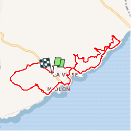
Tocht Stappen van 10,6 km beschikbaar op Provence-Alpes-Côte d'Azur, Bouches-du-Rhône, Le Rove. Deze tocht wordt voorgesteld door ARPF1.
Plaatsbepaling
Land:
France
Regio :
Provence-Alpes-Côte d'Azur
Departement/Provincie :
Bouches-du-Rhône
Gemeente :
Le Rove
Locatie:
Unknown
Vertrek:(Dec)
Vertrek:(UTM)
682775 ; 4801377 (31T) N.
Opmerkingen